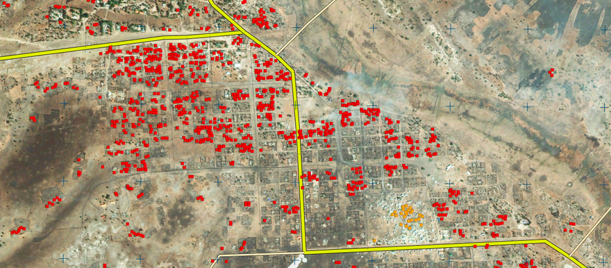
Satellite photographs analyzed by the United Nations shows that 1,556 homes were destroyed in Leer, a town seized by the South Sudanese government from opposition forces.
Leer in south-central Unity State was captured by SPLA at the end of January, about a week after a ceasefire agreement was signed in Addis Ababa, though a state security official told Radio Tamazuj the area was held since before then.
UNOSAT, the satellite programme of the United Nations Institute for Training and Research (UNITAR), is operated in cooperation with the European scientific research agency CERN.
The UN research program published on Friday a map highlighting in red the structures destroyed in Leer town, which presumably were set fire either by advancing government forces or retreating opposition forces.
“This map illustrates satellite-detected areas of destruction in the town of Leer as seen by the GeoEye-1 satellite on 2 February 2014,” reads an explanatory note on the UN document.
“UNOSAT analysed all structures in the town to verify reports of damage and determined that a large portion of the town has been destroyed, primarily by fire. A total of 1,556 burned or otherwise destroyed structures (including tukuls, other residential structures, and outbuildings) were identified throughout the town, as well as 26 destroyed commercial structures,” it added.
The image also shows several active fires and smoke plumes, as well as ‘indications of looting,’ suggesting that the destruction occurred shortly before 2 February when the satellite image was shot.
UNOSAT’s analysis confirms an earlier assessment from the Satellite Sentinel Project, which counted almost 1,100 residential houses burnt in Leer after the fall of the town.
Related coverage:
South Sudan appoints commissioner for conquered town (5 Feb.)
Satellite images of burned homes after fighting in Leer, Unity state (4 Feb.)
South Sudan VP declines comment on who controls Leer (3 Feb.)
South Sudan rebels say army razed town, using foreign fighters (2 Feb.)
Fighting spreads into southern Unity State (31 Jan.)
Photo: Satellite imagery analysis by UNOSAT, 17 February 2014


