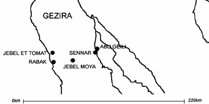
The Sudanese army and the paramilitary Rapid Support Forces (RSF) clashed on Monday over control of the strategic Jebel Moya area, a group of hills located 24 kilometers west of Sennar town in Sennar State.
This conflict comes amid the RSF’s southward expansion from El Gezira State into Sennar State since December, a campaign marred by accusations of civilian rights violations.
The RSF issued a statement claiming its forces had captured the Jebel Moya area, a strategic location linking Sennar, El Gezira, and the White Nile states. Media platforms aligned with the RSF also claimed their forces seized control of Jebel Moya, sharing videos of fighters capturing Sudanese Armed Forces (SAF) military equipment.
Later on Monday, in response to the RSF’s claims of victory in Jebel Moya, SAF propagandists reported that the army had repelled the attack. They also announced that SAF troops had recaptured the Sennar Sugar Factory. However, Radio Tamazuj has not been able to independently verify this information.
Meanwhile, the Sennar Observatory for Human Rights reported that the Rapid Support Forces (RSF) committed crimes against civilians, including looting, intimidation, and house raids in Jebel Moya and surrounding villages.
“A large number of civilians are still trapped in the clashes area, while others have been displaced to safer locations,” the statement read.
The rights group expressed deep concern over these developments, calling for the protection of civilians and the prevention of further violations.
The Observatory also called for an immediate cessation of clashes and urgent international intervention to provide humanitarian assistance to the displaced and affected people.
The war began on April 15, 2023, when Sudanese citizens awoke to sounds of gunfire and clashes in the capital, Khartoum, pitting units of the Sudan Armed Forces against the RSF.
The war quickly spread beyond Khartoum. Since its beginning, more than 8.8 million people have fled their homes and nearly 16,000 fatalities have been reported by the Armed Conflict Location & Event Data (ACLED), a data collection, analysis and crisis mapping project.


