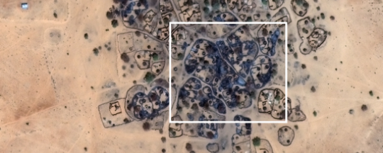
New satellite imagery shows more than 300 burned huts in villages bombed by the Sudanese Air Force and attacked by government-backed militias in Darfur’s East Jebel Marra last week.
The images from the Satellite Sentinel Project, published Thursday, confirmed the attacks on the villages Dolma, Konjara, Korofala, Unjara, Hemeda, and Sendingo in North Darfur. The project, which regularly conducts monitoring of Sudan and South Sudan, assessed satellite images of the mentioned areas on the basis of reports by the United Nations and Radio Dabanga.
The paramilitary Rapid Support Forces (RSF) attacked Dolma, south-west of state capital El Fasher, among other villages, on 15 March. The satellite images show 95 burned huts in the south-central part of Dolma, after “militia troops in 300 vehicles loaded with various weapons plundered the villages”, according to a Radio Dabanga listener. Another 126 huts in the centre of Hemeda, close to Dolma, are visibly burned to the ground on the satellite images.
The images also confirmed earlier reports of the militias’ attacks on Konjara, 53 km west-southwest of El Fasher, on the same day. 57 huts were destroyed in the western part of the village, and 20 huts in the nearby Unjara.
After the ground attacks on these villages, the Sudanese Air Force bombed Korofala (about 10 km north of Dolma) on 16 March. Radio Dabanga reported that Nimra, Dali, and Jebel Dango were hit on that day as well. Ten burned huts, and five bomb craters are seen on images of Korofala, “situated in a linear pattern, spaced consistently apart”, which indicates an indiscriminate multi-munitions air strike, according to the SSP.
The bombardments in this area lasted for at least three consecutive days, according to local sources. On 18 March, Konjara was also bombed after the ground attacks three days earlier, as the satellite images show several bomb craters around the perimeter of the town. Three bomb craters are visible on images of Sendingo, 3 km west of Konjara.
Photo: Hemeda’s burned centre, on a satellite image of 21 March, after being attacked last week (SSP)
Reporting by Radio Dabanga


