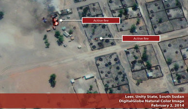
Satellite images from Sunday show a torched Leer town, in Unity state, after fighting in violation of the cessation of hostilities agreement signed by South Sudan’s combatant forces less than two weeks ago.
The Satellite Sentinel Project counted almost 1,100 residential houses on its satellite images from Tuesday that were burned to the ground in Leer during last weekend. Images from January, mostly from before the ceasefire agreement was signed, also showed destroyed civilian homes in Malakal, Bentiu, Mayom, Khor Bow, Rubkona, and Yak villages in the oil-rich Unity state.
The satellite imagery showed torched civilian structures and huts in Leer, which is the home town of former Vice President Riek Machar, who is fighting against President Salva Kiir’s forces. Lul Ruai Koang, a spokesman for the South Sudanese armed forces loyal to Machar, has claimed that government forces “consisting of Justice and Equality Movement units and South Sudan Liberation Army militias” advanced on Leer on Saturday afternoon, according to a report by Voice of America. Current Vice President James Wani Igga declined to comment on Monday on whether the government controls Leer.
Under a ceasefire deal signed on 23 January the government army and the armed opposition agreed not to move their forces from their current positions. Since then both sides have been accused of violating the deal. A team of regional monitors has arrived in the country to observe the ‘shaky ceasefire’, according to the United States on Tuesday (source: Reuters).
According to the United Nations, 188,100 people were already displaced in Unity state as of January 31, 2014. “This latest attack will only increase those numbers”, the satellite project stated, which is not capable of determining “whether the forces that attacked Leer were government soldiers or government aligned militias”.
Malakal
Satellite images of Malakal from 27 January showed at least 210 huts burned to the ground in one of the city’s quarters. In another part of town, images confirmed the looting of a World Food Program (WFP) compound. The organisation has reported its warehouses had been almost completely emptied by looters during recent fighting.
Photos: the images of Leer, Malakal, Mayom, and Bentiu from the Satellite Sentinel Project.
Related:
South Sudan VP declines comment on who controls Leer (3 February 2014)
Fighting spreads into southern Unity State (31 January 2014)
Satellites show Sudan’s plan to launch attack in South Kordofan (29 January 2014)


