


Boundary commission assumes ‘Heglig belonged historically to Unity State of South Sudan’ – RT
Notes on Panthou:Heglig
By Douglas H. Johnson
THE COLONIAL BACKGROUND
The Rueng Dinka territory of Panaru is at the centre of the debate over the location of Panthou/ Heglig. The Rueng, who are now contained within Unity State in the Republic of South Sudan, neighbour the Ngok Dinka and originally were administered along with them as part of Kordofan Province. Their current location in Unity State, and the disputed location of Panthou/Heglig is the outcome of a series of administrative transfers in the early twentieth century.
At the beginning of the Anglo-Egyptian Condominium the Rueng Dinka were found with their cattle as far north as Lake Keilak, in what is now South Kordofan.1 In 1907 it was reported that many of them had left ‘Fanaru [Panaru] in South Kordofan’ for Khor Atar in Upper Nile because of raiding by the Misseriya-Humr.2 By 1913 the Awet section of the Rueng were complaining about further incursions by the Misseriya-Humr on their lands around Lake Jau (or Abiad), where the Awet had settled ‘long before the Arabs came’.3
When the Nuba Mountains became a separate province in 1913 the Rueng sections were divided between the Nuba Mountains and Kordofan. One branch of Rueng was transferred to the neighbouring southern province of Bahr el-Ghazal in the early 1920s, and in1927, following the decision to re-absorb the Nuba Mountains Province into Kordofan, most of the rest of the Rueng were transferred there, too, on the grounds that they were more easily accessible to the administrators of Bahr el-Ghazal and that they were already in close contact with the Nuer of that province. The boundary rectification between the provinces was made at a local level meeting of the neighbouring District Commissioners.4 The Rueng were now split between Bahr el-Ghazal and Kordofan, where some Dinka remained as part of the Southern Kordofan District with its headquarters at Kadugli.5 By 1930, however, all Rueng were transferred to the administration of Upper Nile Province, and in 1931 the provincial boundaries were gazetted as follows:6
As a result of the transfer of the Rueng Ajubba the Rueng Await [Awet] and the Rueng Alorr sections of Dinka from Kordofan to Upper Nile Province, the boundary between these Provinces has been altered as follows:- Commencing from a point on the existing Province Boundary midway between Debba Mongok and Debba Karam Nyet (Lat. 9º 21’ Long 28º 38’) the boundary runs in an easterly direction until it meets Khor Amadgora. Thence northwards to the Bahr el Arab to the Raqaba ez Zarqa at a point ½ mile west of Tibusia, thence along the Raqaba ez Zarqa to ‘Aradeib, thence eastward along Lat. 9º 45’ to the old Kordofan – Upper Nile boundary, thence north along that boundary and continuing along the old Kordofan N.M.P. boundary to Lat. 10º 5’ marked on the map ‘Clump of Heglig’ thence N. Easterly to a point 3 miles due west of the centre of Lake Abyad [Lake Jau], thence due east to the eastern shore of the Lake, thence S.E. through the Fed Abu Finyer to the Rest House at the point where the Tonga-Talodi road crosses the Haqaba south of Abu Qussa, thence up that Raqaba to where it joins the existing Province Boundary.
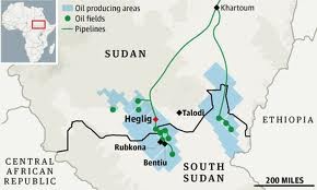
This was the official provincial boundary line in effect when Sudan became independent on 1 January 1956 (see Map 1).
The Sudan Survey 1:250,000 maps 65-H and 65-L on which this boundary was marked (see Map 2), and on which all subsequent maps of the area are based, was last updated for topographical detail in 1937. The area bisected by the line is mainly a blank space. Aside from marking some water sources and the occasional clump of heglig trees Balanites aegyptiaca: hijlij in Arabic and thou in Dinka no villages or annual cattle camps, no place names of ‘Panthou’, ‘Aliny’ or even ‘Heglig’ are recorded. The reason is that this area lay outside administrators’ usual trek routes. The maps record the main lines of communication and main waterways. They document the limits of administrative knowledge, not the full scale of indigenous settlement.
OIL, NAME CHANGES AND ETHNIC CLEANSING
The discovery of oil in the late 1970s created immediate tensions between the central government in Khartoum and the Southern Regional Government in Juba. Oil was declared a national resource, and official announcements from Khartoum were vague about the location of the main oil fields, stating only that they were located some 500 kms south of Khartoum. The first fields to be developed were given names such as ‘Unity’ and ‘Heglig’ which disguised their location, and the Chevron oil company based its headquarters in Muglad rather than Bentiu. In 1980 the national parliament attempted to redraw the boundaries of Upper Nile Province with the passage of legislation establishing new regional governments in northern Sudan, and the map accompanying the legislation annexed the oil fields to Kordofan. This map was withdrawn after protests from the Southern Regional government.
One of the first fields to be developed was at Panthou, meaning ‘the place (or village) of the Balanites aegyptiaca’ in Dinka. The name was changed to Heglig in Arabic. Nimeiri proposed to create a new Unity Region by amalgamating Western Upper Nile District, Abyei and parts of Southern Kordofan, but in the end only Western Upper Nile was renamed Unity when the Southern Region was abolished in 1983 and Upper Nile Region was reconstituted by re-uniting Upper Nile and Jonglei Provinces.
There was also controversy on the siting of an oil refinery to process oil from the field. The decision was made to site the refinery on the White Nile at Kosti, linked to the oil fields by a pipeline. In 1983, shortly before the Bor Mutiny and the outbreak of civil war, an official map of the route of the pipeline was released, showing it starting at the oil fields within Western Upper Nile District, but immediately routed out of Upper Nile into Kordofan, paralleling the Nile until it reached Kosti.7
The civil war brought an end to oil exploitation inside Upper Nile until the 1990s when the Sudanese Armed Forces and allied militias cleared large areas of their civilian populations. The establishment of Sudan’s oil industry in Unity State was accomplished through massive demographic displacement of its indigenous inhabitants, especially along the old provincial boundary lines. The territory of Panaru, in particular, was cleansed of its occupants to make way for the development and expansion of the oil industry.8
Up through 2003 it was generally understood that Panthou, or Heglig, was part of the Unity State administration, and the National Congress Party-appointed governor of Unity State, Dr. Joseph Monytuil described it as such in his 2003 annual report. In mid-2004, as the CPA negotiations were drawing to a conclusion, he was informed by Dr. Nafie Ali Nafie, then Minister of Federal Government Chambers in the office of the Presidency, that he was mistaken, and ‘that Heglig does not belong to Unity State as it appeared in your aforesaid map but it belongs to Western Kordofan State as indicated in the accompanying map approved by the National Survey Corporation, for information and correction of the map of Unity State referred to’.9 The accompanying map identifying this correction is not detailed enough to determine whether Heglig is located in relation to the 1931 provincial boundary line at 29° 32’ (and some seconds), or the line has been moved east in order to include Heglig in Western Kordofan.
It should be noted that the two protocols of the CPA affecting the division of oil revenues – the Wealth Sharing Protocol (7 January 2004), and the Abyei Protocol (26 May 2004) – were signed before the date of Nafie Ali Nafie’s letter (14 June 2004). Placing Heglig in Western Kordofan would therefore have been done in full knowledge that only the revenue from fields within South Sudan would be shared.
HEGLIG AND THE ABYEI BOUNDARIES COMMISSION
It has been commonly asserted that the 2005 Abyei Boundaries Commission (ABC), of which I was a member, allocated Heglig to Abyei, and the 2009 ruling of the Permanent Court of Arbitration (PCA) finally determined that it was part of Sudan. Neither assertion is strictly correct.
The ABC was tasked to determine the territory of the nine Ngok Dinka chiefdoms transferred from Bahr el-Ghazal to Kordofan in 1905. We were enjoined repeatedly by the members of the government delegation not to take into consideration any developments in the territory that post- dated 1905. This meant in practice that the development of cotton cultivation in the Nyama area, the construction of the railroad passing through Meiram, and drilling of oil wells were irrelevant to our deliberations and were not to be a factor in our decision.
The maps we had at our disposal and which we examined for topographical, demographic and historical evidence therefore did not include details of the recent establishment of the oil industry in and around the area. We did ask the Sudan Survey Authority for copies of the most recent editions of the 1:250,000 maps to compare them with the historic maps we had consulted, but we never received the maps we requested.
Our understanding of the oral testimony we gathered from the Ngok and Rueng groups we spoke to was that Ngok and Rueng territories were contiguous, which is, in fact, how they are depicted on the Sudan Survey 1:2,000,000 tribal map of Southern Sudan (Map 1)10. We knew from the historical records referred to above that the Rueng were transferred, bit by bit, from Nuba Mountains, Bahr el-Ghazal and Kordofan to Upper Nile, and that the province boundary drawn on the map in 1931 after the final transfer was complete represented the dividing line between Rueng and Ngok territory. We drew our boundary up to that line, which was also the provincial boundary line in existence in 1956.
The ABC did not push the boundary line east in order to include Heglig in Abyei. Heglig is mentioned only once in passing in our report (as part of an SPLM submission which we did not accept in full), and it does not appear on any of the maps accompanying the report.
If Khartoum moved the boundary to include Panthou/Heglig inside Western Kordofan (as is suggested by Nafie Ali Nafie’s 2004 letter and Map 3), that does not affect our decision in any way, since we were using the 1931 boundary as a fixed point on which we could anchor Abyei’s northern boundary line, not the boundary between Western Kordofan and Unity as it was in 2005. Panthou/ Heglig would have been included in the ABC award only if its location is west of the 1931 boundary line. If its location is in fact east of that line, then it could not have been included in the ABC award.
The PCA did not give the same weight to the oral and historical evidence as we did when reviewing the eastern border of the Abyei Area. Their decision to adjust the boundary was based on their assessment that we had not given sufficient reason in the ABC report for adopting the old Kordofan–Upper Nile boundary as the eastern boundary of the Ngok territory.
The PCA made no ruling about Panthou/Heglig itself, or about any other portion of the 1956 boundary line. To do so would have exceeded their mandate, and had the court exceeded their mandate no doubt the Sudan government would have objected.
The government of South Sudan asserted its claim over Panthou/Heglig shortly after the PCA ruling, stating that the issue of Heglig was still to be resolved in the North-South border demarcation process. They have repeated this in their submissions to the North-South Border Technical Committee and to the African Union High Implementation Panel.11
RESOLUTION
Given the history of the Panaru area outlined above any government or international body that declared that Heglig is ‘internationally recognized’ as part of Sudan has been premature at best and prejudicial to a final resolution at worst.
The question that has to be resolved, in the terms of the CPA, is whether Panthou/Heglig is east or west of the boundary line established in 1931. If east, it is part of Unity State; if west, it is part of Southern Kordofan. If it is part of Unity, it is part of South Sudan; if it is part of Southern Kordofan it is part of Sudan.
We know from the above summary that up through 2003 Heglig was generally assumed to be part of what is now Unity State. The boundary changes proposed in the national parliament in 1980 explicitly acknowledged this, as did the 1983 proposed route for the oil pipeline. If Juba can prove that Khartoum either moved the boundary or falsified the map in 2004 then they win their case.
But it must be remembered that map evidence is only a representation of the situation on the ground. Maps can be imprecise, inaccurate, or false. Testimony, whether documentary or oral, on how the area was administered since 1931 is as important, if not more important, in determining the jurisdiction over Panthou/Heglig. All such evidence should be considered in order to reach a fair and just solution to this dispute.
Please follow link to see full text