


Aerial bombing of Warguet and a violation of South Sudanese territory in Northern Bahr al Ghazal have not been confirmed by independent sources. Radio Tamazuj could not confirm any of the claims made this week by the South’s Army Spokesman Col. Philip Aguer and Minister of Information Barnaba Marial. They alleged that Sudanese warplanes dropped bombs targeting civilians on May 20 and in the following days.
Sources only confirmed fighting in the area of Warguet nearly 20 kilometers north of the 1956 border between Northern Bahr al Ghazal and South Darfur. Warguet is known for the presence of the South Sudanese Army and is described in a recent church mission report as ‘a dangerous place only for soldiers’.
A source in Meiram, a village in South Kordofan, and commanders at South Sudan’s 3rd Division Headquarters confirmed to Radio Tamazuj the outbreak of conflict in the region. A butcher in Meiram reported that the fighting involved Rizeigat militias and South Sudanese troops. He contended that the clashes occurred in the area of the Bahr El Arab River, which is also known as the Kiir River.
Although independent verification in the area was not possible, church visitors authored a report on the situation in Warguet just months before the latest events. In December 2011, church leaders noticed that Warguet and other areas on the south bank of the Bahr El Arab/Kiir river are highly militarized.
Warguet is described as a ‘military barrack’ of the 3rd Division of South Sudan’s army. Bishop Abraham Yel Nhial led the visit together with military chaplains in order to provide spiritual encouragement to soldiers. He traveled in an army convoy to reach Warguet ‘because the whole area was not secure,’ according to the report by the Episcopal Diocese of Aweil.
‘This place is a very dangerous and fearful place even those who have heavy machines hardly come here… it is a dangerous place only for soldiers’, said Lt. Col. Gabriel Door, a commander at Warguet, as quoted in the diocesan report.
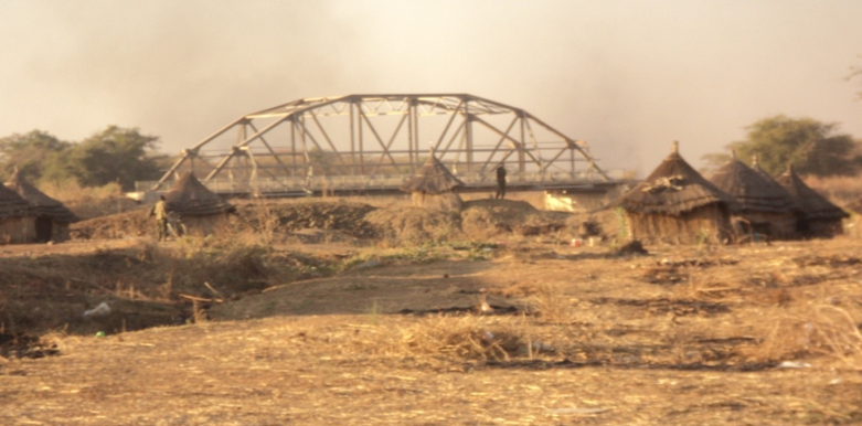
Kiirkou, a railroad bridge at the river several kilometres north of Warguet, is described in the diocesan report as a place ‘inhabited by soldiers only’. Grass-thatched huts in the foreground of a picture of the bridge are occupied by South Sudanese soldiers, the church report notes.
To the north of the Bahr El Arab River are grazing routes and some towns, including Meiram, belonging primarily to Misseriya or Rizeigat Arabs. These are the two largest tribes in the southernmost parts of Darfur and Kordofan. They are heavily armed and have clashed with each other violently in the past. Both Arab tribes rely on seasonal grazing lands along the banks of the river, as well as farther south within the Dinka Malual homeland in Northern Bahr El Ghazal, where they participated in tribal peace conferences with the Dinka in February and March this year.
Khartoum officials allege that forces of the Justice and Equality Movement (JEM) are sheltered south of the river. Sudanese officials linked a previous bombing along the Kiir River to the presence of JEM forces, in November 2010 at the Kiir Adem crossing. Rebel groups have carrried out attacks in the southernmost parts of South Darfur and South Kordofan, including an attack by NRF on an oil facility in Abu Gabra in 2006.
Border dispute
Sudan and South Sudan agree in principle that the boundary as it existed in 1956, the year of Sudan’s independence, should form the basis for the new international boundary between the two regions.
According to a detailed map authored by geographers at the University of Bern Centre for Development and Environment Geoprocessing Unit, who for years have mapped Sudan and South Sudan, the village ‘War Guit’ lies just about 5 kilometres south of the Bahr El Arab/Kiir River along the Wau-Babanusa railway.
If the map is correct, Warguet is north of an administrative boundary set in 1924 to delimit the Rizeigat dar (tribal homeland). The 1924 boundary was established by two British district commissioners to reduce hostilities between the Rizeigat and Dinka. They agreed that the Rizeigat dar reached to 14 miles (22 km) south of the River Kiir/Bahr El Arab. The decision came to be known as the Munro-Wheatley Agreement. Ever since, the border has appeared on maps according to this line rather than the river.
But the Dinka Malual never cared for the Munro-Wheatley Agreement. Local chiefs and military commanders see the south bank of the Kiir as part of their homeland. Some look even farther north. ‘By God’s will, you will not find us here at Warguet but in a Babanusa or Meiram when you visit us next time,’ Col. Gabriel Door tells the visiting Bishop Abraham Yel Nhial. ‘These are areas beyond Warguet, which formerly belong South Sudan but taken by Northern Sudan’.
By Daniel van Oudenaren
Photo by Episcopal Church of Sudan Diocese of Aweil: the Kiirkou Bridge on the Bahr El Arab/Kiir River, just north of Warguet.

 and then