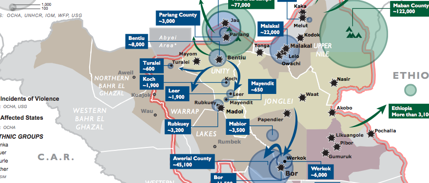
The heaviest violence in South Sudan’s conflict has been in four states, but economic disruptions, violent incidents, and refugee flows elsewhere mean that the impact has been felt nationwide.
A map (PDF) produced by the USAID’s Office of Foreign Disaster Assistance shows refugee flows as well as locations where violence has broken out since 15 December.
The blue circles indicate displacement that has occurred since the start of the civil conflict, whereas green circles show refugee populations that were present in the country since before it started.
According to UN figures, the number of people displaced by the violence is at least 180,000, though that figure does not reflect the amount of displacement in rural areas nor the number of people who have left the country by air or road.
The map does not indicate which ‘incidents of violence’ were most severe or most long lasting, such as the initial conflict within the capital Juba and then the repeated fighting in Bor and Malakal.
Jonglei, Upper Nile, and Unity remain contested or partially under control of opposition forces, whereas Central Equatoria has been overall quiet since the end of clashes in Juba two weeks ago.
Much of the west of the country – namely, Western Equatoria, Western Bahr al Ghazal, Warrap, and Lakes states – has been untouched by direct violence. But the latter two states are labeled as ‘affected states’ presumably because of influxes of people fleeing neighboring states, as well as criminal incidents or minor clashes.
Related:
IDP camp for 25,000 to be established in Juba (31 Dec.)
Public health concerns as number of displaced rises to 180,000 (25 Dec.)


