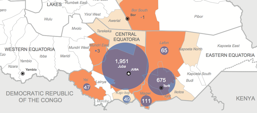
The UN humanitarian office in South Sudan yesterday published a map showing the scope of the cholera outbreak in the country, warning “the humanitarian crisis in South Sudan shows no sign of abating.”
“The rainy season is in progress, and logistics and sanitation challenges have increased. Cholera cases and warnings are on the rise,” stated the UN agency OCHA.
A total of 2,916 cholera cases with 67 deaths (Case Fatality Rate 2.3%) have been reported in South Sudan as of 6 July.
This includes 1,951 cases in Juba County, 49 in Kajo Keji County, 47 in Yei County, and 3 in Mundri East. These areas are around the national capital, where the outbreak began.
Since the outbreak spread to Eastern Equatoria State, at least 675 cases have been recorded in Torit, 65 in Lafon, and 111 in Magwi, with cholera alerts also issued on Kapoeta North and Ikotos counties of the same state.
The map shows cholera ‘alerts’ for Malakal and Rubkona counties of Upper Nile and Unity states, but not the number of cases there, though hundreds of suspected cases were reported in Wau Shilluk in Upper Nile.
In total, close to 1.5 million people have fled their homes since December 2013, with the largest population of displaced in Jonglei state, and about a third to half of the population of Unity state also displaced.
For breaking news updates from Radio Tamazuj ‘like’ our page on Facebook, follow us on Twitter, or subscribe to our RSS feed.


