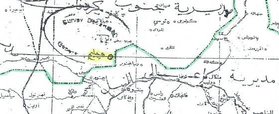
A widely published British historian disclosed that Presidential Advisor Dr. Nafie Ali Nafie in 2004 instructed the Governor of Unity State that Heglig oil field belonged to West Kordofan State, and produced a map to prove the point.
Dr. Douglas Johnson, whose publications include books on the Nuer prophets and the second Sudanese civil war, circulated a note May 2 on the Heglig boundary dispute. In the note the historian wrote that Nafie’s 2004 letter may suggest that “Khartoum moved the boundary to include Panthou/Heglig inside Western Kordofan.”
Dr. Nafie, then serving as Minister of Federal Government Chambers, instructed Governor Monytuil “that Heglig does not belong to Unity State as it appeared in your aforesaid map but it belongs to Western Kordofan State as indicated in the accompanying map approved by the National Survey Corporation, for information and correction of the map of Unity State referred to.”
Western Kordofan State no longer exists but rather is now part of South Kordofan State, which is in the Republic of Sudan, whereas Unity State is now in the Republic of South Sudan.
The map published by Dr. Johnson shows ‘Heglig’ written clearly north of the Unity/Kordofan border, with a circled place indicator. The written place name appears orthographically different from the Arabic handwriting and typeface used on the rest of the map.
The letter, dated 14 June 2004, was written just months after the signing of the Wealth Sharing Protocol (7 January 2004) and Abyei Protocol (26 May 2004) of the ‘Comprehensive Peace Agreement’.
According to Dr. Johnson, the letter suggests that Heglig was ‘generally understood’ to be part of the Unity State administration until 2003. Johnson noted that “the National Congress Party-appointed governor of Unity State, Dr. Joseph Monytuil described it as such in his 2003 annual report.”
“If Juba can prove that Khartoum either moved the boundary or falsified the map in 2004 then they win their case,” stated the historian.
Sudan’s army briefly lost control of Heglig oil field in mid-April during serious fighting with South Sudan’s army and allied elements of the Sudan Revolutionary Front including the Justice and Equality Movement and SPLA-North.
The loss of the oil field provoked fury in the Sudanese capital and resulted in orders for a general mobilization. Internationally, a number of countries condemned the incursion by the South Sudanese army.
Although Sudan has re-occupied the territory, South Sudan has note given up their claim. Barnaba Marial Benjamin, Minister of Information for the Juba government, stated April 20 that “the decision to pull out of Heglig is without prejudice to our stand that it remains an integral part of South Sudan.”
The Permanent Court of Arbitration in The Hague, in its ruling in 2009 to delimit the Abyei Area, produced a map showing ‘Heglig/Meding’ on the Kordofan side of the 1956 provincial boundary. The ruling, however, did not strictly address Heglig’s location, and South Sudan now claims the territory as part of Unity State, not Abyei.


