


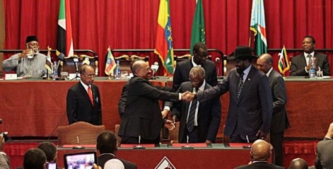
Sudan and South Sudan agreed on 27 September to form a committee for demarcating the boundary between the two countries, and set guiding principles for how the committee will carry out that work. They also agreed that the border will be a ‘soft’ one, allowing nomadic communities and trade to cross easily. The agreement was part of a package of deals negotiated in Bahir Dar and Addis Ababa in Ethiopia under the mediation of the African Union.
Excerpt: “The two States affirm the definition of the agreed boundary in accordance with the physical description and delimitation, and corresponding recommendations of the Technical Committee for the 1/1/1956 Border Line Demarcation Between North and South Sudan, as affirmed by the Presidency of the Republic of the Sudan prior to the secession of Southern Sudan.”
Background: The boundary between the two countries should lie along the 1956 colonial border delimiting the South Sudan region within Sudan at the time of independence from the British. This principle dates to the 2005 Comprehensive Peace Agreement between Sudan and the SPLM rebels who now rule South Sudan. However, the 1956 boundary is problematic because colonial administrators and geographers did not always precisely demarcate the border, not even on maps. In addressing this problem, the two sides had earlier formed a technical committee to compare the current landscape (‘physical description’) with colonial-era descriptions and maps (‘delimitation’). The countries’ two leaders empowered this technical committee by decree, but its work stalled anyway: the phrase ‘as affirmed by the Presidency’ is an oblique reference to this earlier consensus between Omar Al Bashir and Salva Kiir, who was formerly First Vice President of Sudan’s National Unity Government and hence party to presidency decisions.
Implications: The two sides will form a Joint Demarcation Committee which will have the difficult task of setting the boundary in disputed areas including the Kafia Kinji enclave in the far west, the Safaha or ‘Mile 14’ area between Darfur and Northern Bahr El Ghazal, the oil-rich grasslands between South Kordofan and Unity State, and agricultural lands around northern Upper Nile.
Not to be confused… Abyei, often referred to as a disputed border territory, is the only part of the north-south border not subject to the principle of demarcation along the 1956 border. Both sides acknowledge that Abyei was part of north Sudan in 1956 but agreed to a separate political solution for the region, which was supposed to be determined by a referendum in early 2011 concurrent with the South Sudan referendum.

 and then